
")
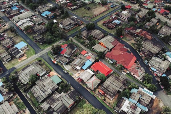
In the world of construction, there are few technological breakthroughs as transformative as the fusion of LiDAR and drones. This combination has set the stage for an evolution in survey methods, paving the way for unprecedented levels of detail and accuracy. At the heart of this innovation lies UAV LiDAR mapping—a technique that’s rapidly redefining how construction managers and overseers approach their projects.
LiDAR, or Light Detection and Ranging, is not a new technology in itself. For years, it’s been leveraged in various sectors for its unparalleled ability to capture detailed spatial data. However, when combined with the versatility and reach of drones, it takes on a new dimension. From capturing vast terrains in high resolution to ensuring survey-grade absolute accuracy, UAV LiDAR mapping is a game-changer.
As the demands of construction projects grow more complex, and the importance of accurate 3D models becomes even more paramount, understanding the nuances and potential of drone LiDAR is essential. Whether you’re a seasoned construction professional or just dipping your toes into the possibilities of LiDAR solutions, this guide will illuminate the capabilities, benefits, and transformative potential of this powerful pairing.
What is LiDAR and Why is it Revolutionary?
LiDAR, an acronym for Light Detection and Ranging, stands as a pivotal technology in the realm of spatial data collection. But what exactly is LiDAR, and why has it emerged as a revolutionary tool, especially when integrated with drones?
The Basics of LiDAR: LiDAR operates on a relatively simple principle: it uses laser pulses to measure distances. These lasers bounce off objects and return to the LiDAR sensor. By calculating the time it takes for each pulse to return, it’s possible to determine the distance between the sensor and the object. This process is repeated millions of times in quick succession, resulting in a dense and detailed “point cloud” of data that represents the surveyed environment.
LiDAR vs. Traditional Surveying Methods: Traditional surveying methods often involve manual measurements and can be time-consuming, labor-intensive, and sometimes even risky, especially in challenging terrains. LiDAR, on the other hand, offers a non-intrusive way to gather data rapidly. Its capability to capture high accurate measurements, even in dense vegetative areas or over uneven terrains, gives it a considerable advantage. Moreover, when this technology is mounted on drones, surveyors can access regions that might have been otherwise unreachable or unsafe.
The Revolution of LiDAR Technology in Data Collection: LiDAR’s true marvel lies in the depth and quality of data it captures. The generated 3D point cloud offers a high-resolution depiction of the environment, capturing everything from the lay of the land to the intricacies of structures. This kind of detail is invaluable in fields like construction, where understanding the nuances of a site can mean the difference between project success and costly overruns.
The Broader Implications of LiDAR: Beyond just measurements, LiDAR technology plays a significant role in creating Digital Terrain Models (DTM). These models provide an unobstructed view of the land’s features, eliminating obstacles like vegetation. For construction managers and overseers, this means a clearer understanding of the project site, facilitating better planning and execution.
The revolution of LiDAR isn’t just about faster surveys or accessing hard-to-reach areas; it’s about ushering in a new era of data collection. An era where detailed, high-quality information drives decisions, making projects more efficient, accurate, and aligned with the demands of modern construction.
Integrating LiDAR with Drones: An Overview
When LiDAR technology converges with the world of unmanned aerial vehicles (UAVs), the synergy creates a dynamic platform that’s reshaping industries. But how does this integration work, and why is it proving to be a significant advancement in the field of data collection and mapping?
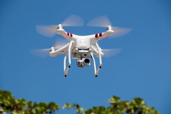
The Birth of Drone LiDAR: Historically, LiDAR systems were bulky and often reserved for larger aircraft or ground-based setups. As LiDAR sensors became more compact and affordable, they found a new ally in drones. These lightweight UAVs, with their ability to fly lower and navigate challenging terrains, became the ideal vehicle for lidar payloads, bringing high-resolution LiDAR mapping to a broader audience.
The Components of a LiDAR Drone: A LiDAR-equipped drone is more than just a UAV with a LiDAR sensor attached. Several components work in tandem to achieve optimal results:
- LiDAR Sensor: The heart of the system, responsible for emitting and receiving laser pulses.
- GPS System: Ensures that the drone’s position is tracked in real-time, contributing to data accuracy.
- Inertial Measurement Unit (IMU): Helps track the drone’s orientation and velocity, vital for accurate data collection.
- Onboard Data Storage: Captures the vast amount of lidar data generated during a flight.
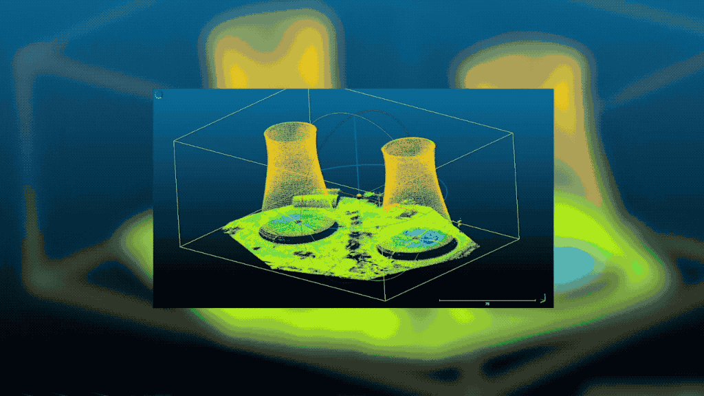
The Power of 3D Point Cloud Data Collection: When a drone embarks on a LiDAR survey, it captures millions, if not billions, of data points. These data points culminate in a 3D point cloud, a digital representation that is both detailed and three-dimensional. For construction managers, this offers a comprehensive view of a site or structure, allowing for meticulous planning, modeling, and assessment.
Advantages Over Traditional Aerial Surveys: While traditional aerial surveys from helicopters or airplanes provide valuable insights, drone lidar mapping stands out in several ways:
- Accessibility: Drones can navigate tight spaces, fly at lower altitudes, and access challenging or hazardous areas.
- Resolution: Due to their ability to fly closer to the ground, drones often capture higher resolution data.
- Cost-Effectiveness: Eliminating the need for manned flights can lead to significant cost savings.
- Flexibility: Drones can be deployed quickly, making them ideal for projects with tight timelines.
Real-world Applications in Construction: From initial site assessments to monitoring progress, LiDAR-equipped drones find myriad applications in construction:
- Site Analysis: Before breaking ground, drone lidar can provide a comprehensive overview of a site, highlighting potential challenges.
- Volume Calculations: For projects involving excavation or fill, LiDAR can provide precise volume measurements.
- Infrastructure Inspection: Bridges, towers, and other structures can be surveyed in detail, aiding in maintenance and safety checks.
Merging LiDAR technology with drones isn’t merely an act of technical integration. It represents the next phase in spatial data collection, offering industries, especially construction, a tool that is precise, efficient, and transformative. As construction projects strive for greater accuracy and efficiency, the role of drone lidar solutions will only become more pivotal.
The Importance of High-Quality and High-Resolution Data
In the realm of construction, the adage, “the devil is in the details,” rings especially true. Every minor discrepancy or oversight can have significant implications on project outcomes, costs, and timelines. This is where the inherent value of high-quality and high-resolution LiDAR data comes into sharp focus.
Defining “High-Quality” and “High-Resolution” in LiDAR Context:
- High-Quality: Refers to the accuracy and reliability of the LiDAR data. It means that the data points captured closely represent the actual physical environment with minimal errors.
- High-Resolution: Pertains to the density of the data points. Higher-resolution LiDAR data will have more data points over a given area, offering a more detailed depiction of the terrain or structure.
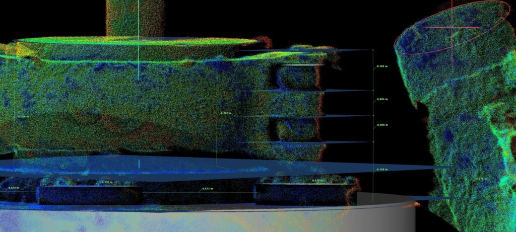
The Nuances of Absolute Accuracy: Absolute accuracy isn’t just about how close a measurement is to a real-world value; it’s the backbone of “survey grade” data. In construction, where millimeters can matter, ensuring that LiDAR data has absolute accuracy is paramount. It guarantees that the 3D models derived from the data can be trusted for crucial decision-making.
The 3D Point Cloud: A Visual Revelation: A dense 3D point cloud is the tangible outcome of high-resolution LiDAR data. This visual representation is rich in detail, providing layers of information about a site or structure. For construction managers, it means an invaluable tool for analysis, planning, and validation.
Implications for Construction Projects:
- Precision Planning: High-quality data allows for meticulous planning, reducing the chances of costly errors or adjustments down the line.
- Risk Mitigation: Detailed insights into the terrain or existing structures can highlight potential challenges, enabling proactive risk management.
- Cost Savings: Accurate data reduces the need for repeated surveys and minimizes unforeseen challenges, leading to tangible cost savings.
- Improved Communication: Detailed 3D models can be shared with stakeholders, ensuring everyone has a clear and unified understanding of the project.
Setting the Gold Standard with LiDAR Solutions: While traditional survey methods might offer decent quality data, LiDAR solutions, especially when paired with drones, set a new benchmark. The combination of speed, accuracy, and detail ensures that construction projects have the best possible data at their disposal.
In today’s construction landscape, where efficiency and precision are non-negotiable, the importance of high-quality and high-resolution data is undeniable. LiDAR technology, with its promise of detailed and accurate 3D models, emerges as an invaluable ally. For construction managers and overseers, understanding and harnessing this data is not just an advantage; it’s a necessity in the pursuit of excellence.
Advantages of Using LiDAR Drones in Construction
The amalgamation of LiDAR technology with drones has opened up a treasure trove of possibilities for the construction industry. Here, we delve deeper into the manifold benefits this fusion brings to the table, redefining traditional surveying methods and construction practices.
Speed and Efficiency:
- Quick Deployments: Drones can be launched rapidly, allowing for swift data collection, especially when compared to traditional ground-based survey methods.
- Broad Coverage: In a single flight, drones can cover vast expanses, ensuring comprehensive data collection in a fraction of the time.
Enhanced Accessibility:
- Difficult Terrains: Drones effortlessly navigate challenging or hazardous terrains, areas that might be inaccessible or unsafe for human surveyors.
- Dense Vegetation: LiDAR can penetrate dense foliage to create a Digital Terrain Model (DTM), revealing the underlying topography.
Unparalleled Accuracy:
- High-Resolution Data: LiDAR drones can capture high accurate measurements, creating detailed 3D point clouds that form the basis for precise 3D models.
- Absolute Accuracy: The integration of LiDAR with drones ensures survey grade data, vital for construction projects where accuracy is paramount.
Cost-Effectiveness:
- Reduced Manpower: Automating the surveying process with drones can lead to a significant reduction in labor costs.
- Minimized Re-surveys: With the high accuracy and detail provided by LiDAR drones, the need for repeated surveys due to missing or erroneous data is diminished.
Flexibility and Scalability:
- Multiple Applications: From pre-construction site analysis to ongoing project monitoring, LiDAR drones fit seamlessly into various stages of construction.
- Scalable Solutions: Whether surveying a small plot or a massive construction site, drone-based LiDAR solutions can be scaled to fit the project’s needs.
Comprehensive Data Analysis:
- Rich Data Sets: LiDAR drones don’t just provide topographical data; they can capture intricate details of existing structures, utilities, and more.
- Intuitive Visualizations: The resultant 3D models and maps offer stakeholders a visual tool for better understanding, planning, and decision-making.
Enhanced Safety:
- Minimized Fieldwork: With drones handling surveys, the need for surveyors to physically traverse potentially dangerous sites is reduced, enhancing overall project safety.
- Structural Inspections: Drones equipped with LiDAR can safely inspect hard-to-reach or deteriorating structures, helping identify potential risks.
The multifaceted advantages of using LiDAR drones in construction go beyond just improved data collection. They encompass every facet of the construction lifecycle, from initial planning to project execution. For construction managers and overseers, adopting drone LiDAR solutions is not just a step towards modernization; it’s a leap towards achieving unmatched project precision, efficiency, and success.
Choosing the Right LiDAR Drone for Construction
LiDAR-equipped drones are transforming construction sites, but not all drones are created equal. Depending on the specifics of a project, the requirements for a LiDAR drone can vary significantly. How then, should construction managers and overseers navigate this terrain and select the ideal drone for their needs?
Assessing Project Requirements:
- Scope of the Project: Is the construction site expansive, or is it a more localized project? The size and scale will influence the drone’s endurance and coverage requirements.
- Terrain and Environment: Rocky terrains, water bodies, or dense forests all demand different LiDAR specifications.
- Desired Data Detail: Depending on the construction phase, the resolution and detail required from the LiDAR data might differ.
Understanding LiDAR Sensor Capabilities:
- Range and Resolution: Different sensors can capture data at varying ranges and resolutions. Ensure the sensor aligns with the project’s accuracy requirements.
- Number of Returns: Some LiDAR sensors can capture multiple returns from a single laser pulse, beneficial in vegetative environments.
Drone Specifications to Consider:
- Battery Life: Determines how long a drone can remain airborne, directly influencing the area it can cover in a single flight.
- Payload Capacity: Ensure the drone can comfortably carry the LiDAR sensor along with any additional equipment, like cameras or additional batteries.
- Stability and Reliability: In construction sites, drones need to navigate varied terrains and withstand environmental factors like wind.
Data Processing and Software Compatibility:
- Real-time Data Processing: Some advanced drones offer real-time data visualization, beneficial for on-site decision-making.
- Software Integration: Ensure the drone’s data output is compatible with the construction management software or any other platforms used for analysis and planning.
Safety and Regulatory Compliance:
- Geofencing Capabilities: Some drones come with features that prevent them from entering restricted areas, ensuring regulatory compliance.
- Collision Avoidance: Essential for flying in areas with obstacles or within busy construction sites to prevent accidents.
- Certifications: Depending on the region, certain certifications or approvals might be necessary to operate drones for commercial purposes.
Training and Support:
- Ease of Use: While LiDAR drones are advanced, their operation should be intuitive, especially for construction professionals who might not be drone experts.
- Vendor Support: Consider manufacturers that offer robust after-sales support, training, and software updates.
Budgetary Considerations:
- Total Cost of Ownership: Beyond the initial purchase, consider costs related to maintenance, software subscriptions, or potential upgrades.
- Return on Investment: While high-quality LiDAR drones can be an investment, their potential for cost savings, efficiency, and data accuracy in construction projects often justifies the cost.
Choosing the right LiDAR drone is a delicate balance between technical requirements, budgetary constraints, and desired outcomes. For construction managers, investing time in understanding these aspects can pave the way for the successful integration of drone technology, ensuring projects are executed with the highest standards of accuracy and efficiency.
Conclusion
The fusion of LiDAR technology with drones is more than just a technological marvel—it’s a testament to how innovative tools can revolutionize traditional industries. For construction managers and overseers, understanding the intricacies of “UAV LiDAR mapping” is no longer a futuristic luxury but a present-day necessity. The advantages are manifold: unparalleled data accuracy, cost savings, enhanced safety, and project efficiencies.
Yet, as with all tools, it’s not just about possession but about adept utilization. The right drone, equipped with the right LiDAR sensor and piloted with the right understanding, can be the difference between a project’s success and failure. As we stand at the crossroads of innovation, embracing and integrating these advancements is the key to molding a future where construction projects are not just structures but monuments of precision, efficiency, and technological prowess.
To all construction professionals reading: the future isn’t on the horizon; it’s here. And it’s time to soar to new heights with UAV LiDAR mapping.